GA 7021 – Northumberland Discount
Description
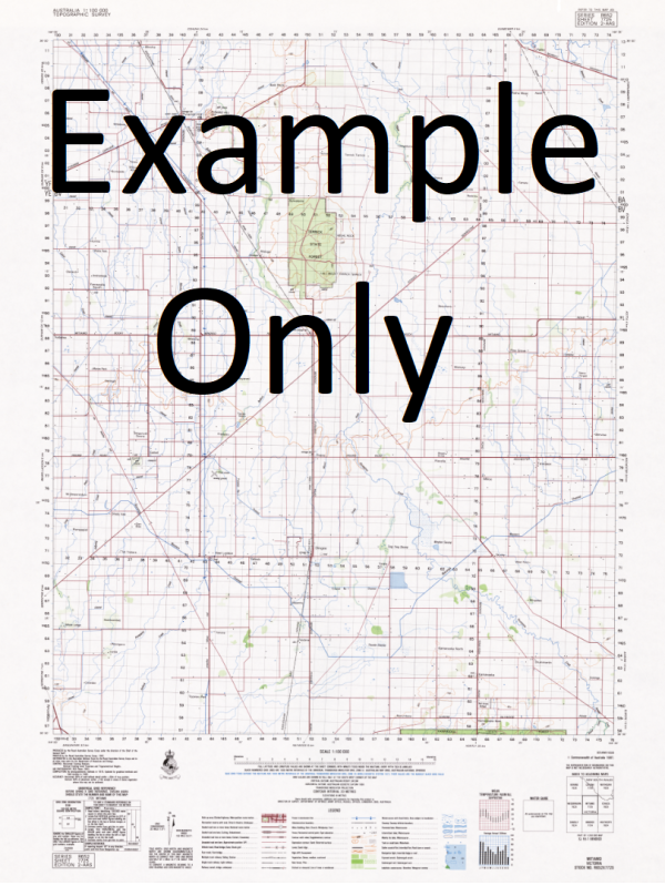
This Topographic Map is produced by Geoscience Australia; Australia s national geospatial organisation.
GA topographic maps (many of which are produced in partnership with the Army) are generally older than those maps produced by the State Governments over the same area. This makes GA maps particularly useful for identifying historic features, such as old mines and diggings.
Geoscience Australia maps generally considered to be more pleasing in design and compilation then the more modern State Government productions.
At this scale, 1cm on this map represents 1km on the ground. A standard map (which is square) covers an area of approximately 54km by 54km, with a contour interval of 20m. This map contains natural and constructed features including road and rail infrastructure, vegetation, hydrography, contours, localities and some administrative boundaries.
Please note the date of the map, as this will impact the currency of information, particularly regarding infrastructure, roads, etc.
Merna Port Macdonnell Allendale East Racecourse Bay Glenorleigh Ngaranga Glenamble Milsteads Pond Cap Mont Blanc Douglas Point Douglas Island Majuro Ewens Ponds Morella Kaydale Windmere Kiriwina Tenterden Reserve Cape Northumberland Glenro Middle Point Stony Point Donovans Eight Mile Creek Telephone Exchange Allendale Sinkhole Fishermans Wheel Memorial Adelaide Cremore Estate The Prong Glenelg River Spencer Pond Drain Milstead Main Drain Eight Mile Creek Hitchcox Main Drain Deep Creek Outlet No 1 Milstead Main Outlet Jerusalem Creek Galatea No 2 Milstead Branch 3 Drain Deep Creek Branch 1 Drain Badenoch Branch Drain Hitchcox Branch 1C Drain Hitchcox Branch 4A Drain Badenoch Branch 2 Drain Eight Mile Creek Branch 2 Drain Eight Mile Creek Branch 5 Drain Eight Mile Creek Branch 4 Drain Flinders Witness Jane Lovett Kangaroo Cove MacDonnell Bay Umpherstone Bay French Garden Tecoma Estate Clarke Park Port MacDonnell Football Club Gum Island Stratman Pond Penbrae Bandicoot Spencer Pond Brown Beach Germain Flora and Fauna Reserve Mount Ruskin Willow Vale 54 Foot Pond Careenya Danger Cape Deep Creek Branch 3 Drain Deep Creek Drain Port MacDonnell Hitchcox Branch 1E Drain The Teeth Glenfinis Clarke Park Picnic Reserve Southern Cross Danger Point Ewens Ponds Conservation Park Douglas Point Conservation Park Lower Glenelg River Conservation Park Jones Bay Cap du Mont St Bernard Volunteer Park Pawer Janannie Dingley Dell National Pleasure Resort No 2 Milstead Branch 1 Drain Cape View Leabrook Ruby Rock Delmarant Woolwash Caravan Park Mary Lattin Memorial Library Lellman No 2 Milstead Main Drain Piccaninnie Ponds Conservation Park John Ormerod Hitchcox Branch 4 Drain Dead Pond Prince of Wales Ewens Creek Deep Creek Hitchcox Branch 1 Drain The Glen Wild Dog Main Drain Hitchcox Branch 1B Drain Green Point Piccaninnie Ponds Araluen Smith Pond Lions Park Picnic Area E A Milstead Health Centre Bones Ponds Four Winds French Point Dead Pond Supply Channel Cress Creek Eight Mile Creek Branch 6A Drain Glen Ro Wilke Pond Cape Douglas Beltana Flying Cloud Wingara Wild Dog Branch 1 Drain Eight Mile Creek Branch 7B Drain Bubbling Spring Baronga Kayannie Lotus Butte Reef Armagh Miami Black River Hitchcock Main Drain Hitchcox Branch 2 Drain Rhino Rock Tenterden Gallery Flint Point Old Reviver Eight Mile Creek Drain Donovans Reserve Douglas Point Trig Aralven Allendale East Area School Central Park Harbor of Port MacDonnell Eight Mile Creek Branch 6 Drain No 1 Milstead Main Drain Discovery Bay Blanche Bay No 2 Milstead Branch 2A Drain Eight Mile Creek Branch 2B Drain Port MacDonnell Police Station The Catherdral Orwell Rocks Hillview Tea Tree Cave Eight Mile Creek Branch 7 Drain Nautilus Badenoch Main Drain Dingley Dell Iron Age Marna-Vale Glen-Gorleigh Pointe des Coreaux No 1 Milstead Branch 3 Drain Eight Mile Creek Branch 3A Drain Earls Cave Piccaninnie Ponds National Park Anse des Pecheurs Summer Hill Oasis Frog Rock Ocean View Port MacDonnell Post Office Eight Mile Creek Branch 2A Drain Finger Point St Marc Tenterden James Corcoran Breakwater 54 Feet Pond Drain No 1 Milstead Branch 5 Drain Jetty Rock Wye Boronga Narrawa St Elmo Port MacDonnell Golf Club Pretty Pond Rock Cavern Hitchcox Branch 2A Drain Hitchcox Branch 2B Drain Hitchcox Branch 4B Drain Hitchcox Branch 1A Drain Eight Mile Creek Branch 3 Drain Hines Bay Piccaninnie Blue Lake Riddoch Bay Miame No 1 Milstead Branch 1 Drain Thomas Ewen Spring Ponds Glen Countess Pond Main 5 Drain Port MacDonnell Sailing Club Warreanga Cape Northumberland Lighthouse Winterfield Creek Brown Bay Anse des Petrels Hole-in-the-Road Eight Mile Branch Creek 2C Drain Nangkita The Point Port of Glenelg River Les Doux Cousins No 2 Milstream Branch 2 Drain Caroline Dingley Dell Conservation Park Donovans Landing Hi-Winds Shelly Beach Allandale East Baie D Estaing Cap Belidor Cap Boufflers Cap du Chameau Baie DEstaing
Additional Information
| Title | Paper, Laminated |
|---|
Related products


linkresortus.shop © 2025 All Rights Reserved