GA 7030 – Chowilla Discount
Description
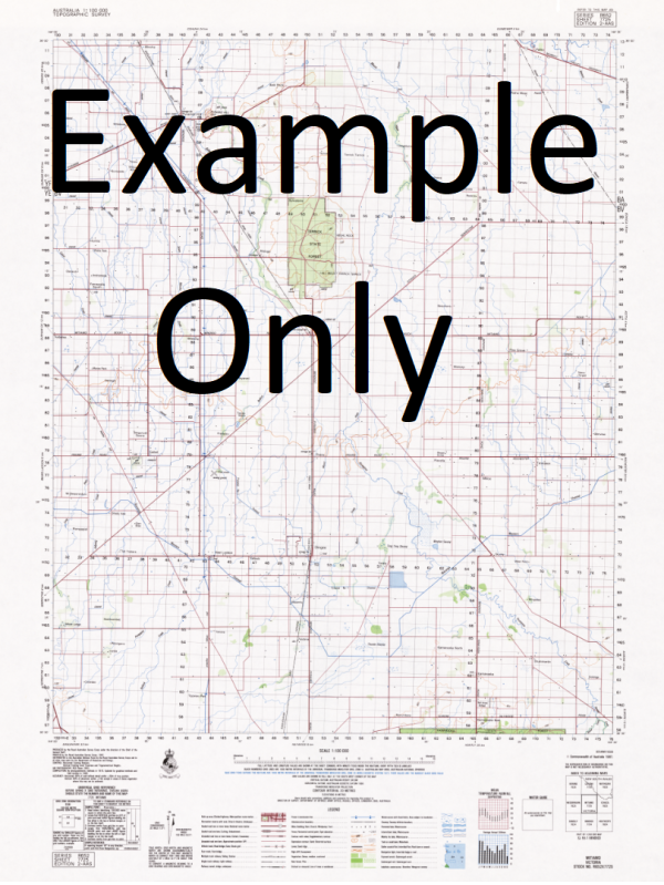
This Topographic Map is produced by Geoscience Australia; Australia s national geospatial organisation.
GA topographic maps (many of which are produced in partnership with the Army) are generally older than those maps produced by the State Governments over the same area. This makes GA maps particularly useful for identifying historic features, such as old mines and diggings.
Geoscience Australia maps generally considered to be more pleasing in design and compilation then the more modern State Government productions.
At this scale, 1cm on this map represents 1km on the ground. A standard map (which is square) covers an area of approximately 54km by 54km, with a contour interval of 20m. This map contains natural and constructed features including road and rail infrastructure, vegetation, hydrography, contours, localities and some administrative boundaries.
Please note the date of the map, as this will impact the currency of information, particularly regarding infrastructure, roads, etc.
Amil Dam Gum Flat Pipeclay Creek Nunthung Salt Creek Sir Henry Young Reef Twenty Nine Mile Dam Hypurna Butcher Dam Coomooloo North Dam Coombool Swamp Two Flats Dam Big Dam Don Dam Boat Creek Wotan Dam Amelia Dam New Paradise Dam Lock 6 Lunatic Bridge Doirane Dam Border Cliffs Nil Nil Queen Reach Timor Hut Dam Twenty Three Mile Dam Doiran Dam Catalogue Dam Eighty Fourth M P Dam Lake Littra Crossing Lake Limbury Bookmark Biosphere Reserve Chowilla Island Timor Dam Borehole Dam Red Bank Tank Bunyip Reach County of Hamley East Oak Tank Pilby Creek Jack Hall Hut Queen Sandhill Monoman Creek Stanley Island Reedy Island No 1 Dam Queen Bend Frogamerry Hut Amalia Dam Monoman Dam Yabbie Tank Jack Hall Dam Wade Tank Burnt Camp Pumphouse Tanks Hideaway Hut Old Coach Swamp Chunkey Hut Thirty Thousand Tank Horseshoe Billabong Triangle Bore Woolshed Quarters Tom Baths Shack Jack Dam Simpsons Dam Oak Bore House Dam The Big Dam Coombs Dam 30000 Tank Chowilla Game Reserve Chunkey Dam Slaney Island Slaney Weir Billabong Lake Werta Wert Wade Dam Rose Dam Hancock Creek Johnson Yard Cane Grass Dam Isle of Man Grand Junction Island Old Coombool Homestead Old Customs House Paradise Shed No 3 Tank Twin Dam Timor Outstation Johnson Dam Square Dam Boat Creek Swamp Oak Tank Burnt Camp Pumphouse Slaney Creek Danggali Conservation Park Chowilla Regional Reserve White Elephant Dam Giles Dam Small Dam Yarraman Yards Emu Dam Yard Johnson Catch Twin Dam Tank Oak Catch Lake Limbra Rotten Lake Newena Island Monoman Island Oak Shed Bertram Dam Boundary Bend Twins Dam Coombool Outstation Pepper Tree No 3 Pumpshed Calperum Pastoral Lease Scientific Reserve Seven Mile Tank Timor Hut Old Well Boat Creek Island North Coombool Dam Boundary Pastoral Run Madman Bridge Murtho Post Office Nell Dam No 2 Dam Frogamerry Dam Salt Creek Post House Paradise Outstation Coppermine Waterhole Lake Littra Horseshoe Lagoon Box Tree Waterhole Honards Tank Nelwood New Coombool Outstation Winack Dam Round Dam Wilperna Island Monoman Tank Frogamerry Tank Punkah Creek Emu Dam Old Timor Dam Suicide Bridge Gunyah Dam Tilmy Dams Nanya Dam Four Corners Crutching Shed Werta Wert Alick Dam Brandy Bottle Waterhole Canegrass Dam Paradise Dam Wyndarra Dam Burnt Camp Dam Punkah Island Fiscom Dam Canopus Number Two Dam Number One Dam Pepper Tree Motel Paradise Long Dam Coombool Doriane Dam Bunyip Beach
Additional Information
| Title | Paper, Laminated |
|---|
Related products


linkresortus.shop © 2025 All Rights Reserved